

Looking for a hike that gives you big rewards without eating up your whole day? Storm King Mountain stands out as one of the Hudson Valley’s most popular trails, and I understand why after hiking it multiple times.
This moderate hike packs serious views into a manageable distance. In just a few hours, you’ll climb through rocky terrain, reach multiple overlooks, and stand atop a summit with 360-degree views of the Hudson River.
This guide covers everything I’ve learned about the trail. You’ll get route options, what to expect on your climb, navigation tips, and practical advice to make your hike smooth and safe.
Storm King Mountain Trail Routes Overview
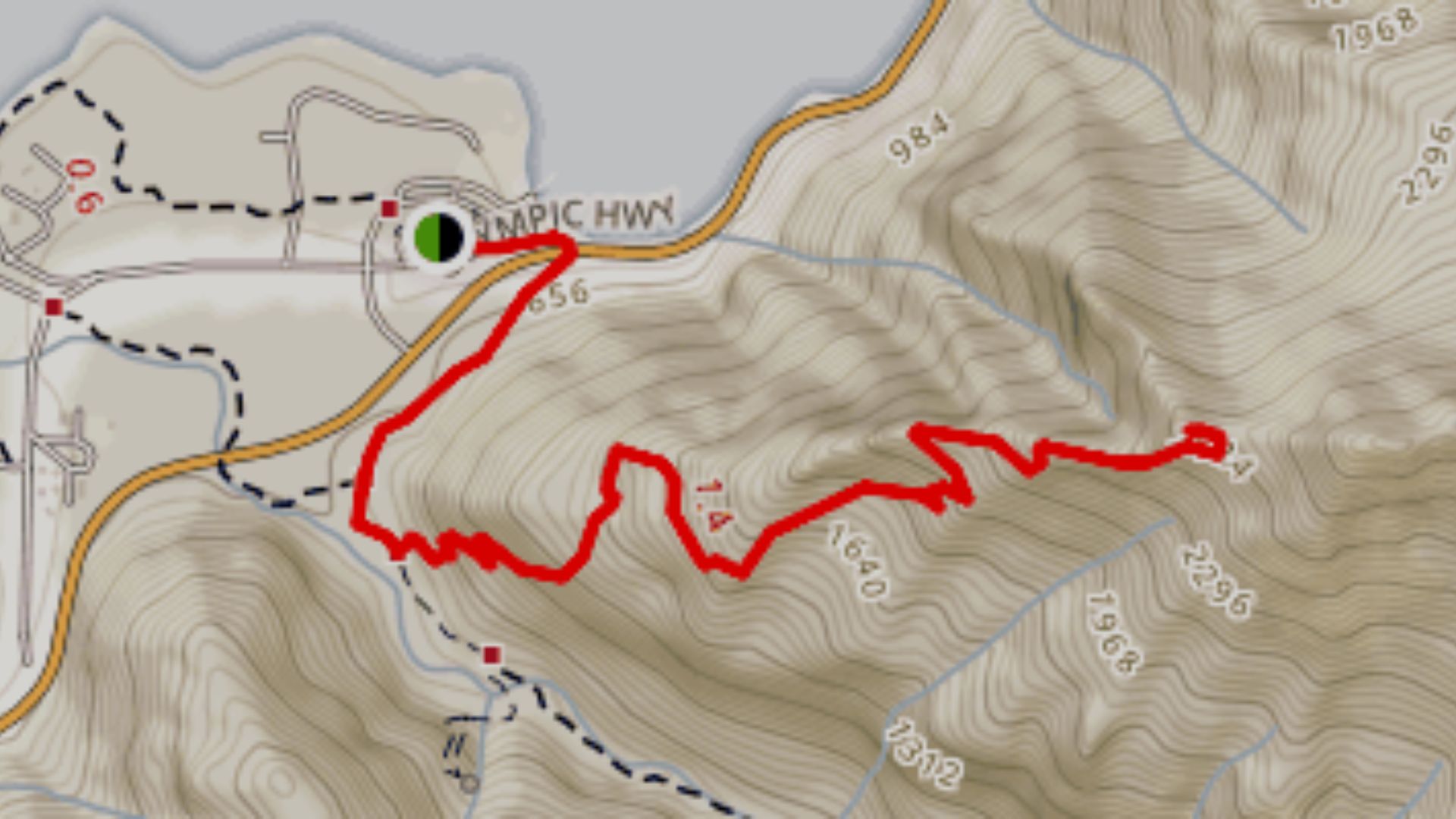
The Storm King Mountain hike offers two main routes. The full Storm King Mountain Loop covers 3.6 miles with 1,102 feet of elevation gain, taking most hikers 2.5 to 3.5 hours. You’ll get the complete experience with views from multiple peaks.
The shorter option, Storm King via Storm King Trail, runs 2.3 miles with 633 feet of elevation gain. This out-and-back route still gives you the main summit views but cuts down on time.
The trailhead sits on Route 9W in Cornwall-on-Hudson. Parking is limited to a small lot that fills up quickly on weekends, so arrive early.
What to Expect on the Trail?
Get ready for a workout right from the start. Here’s what you’ll encounter on your way to the summit.
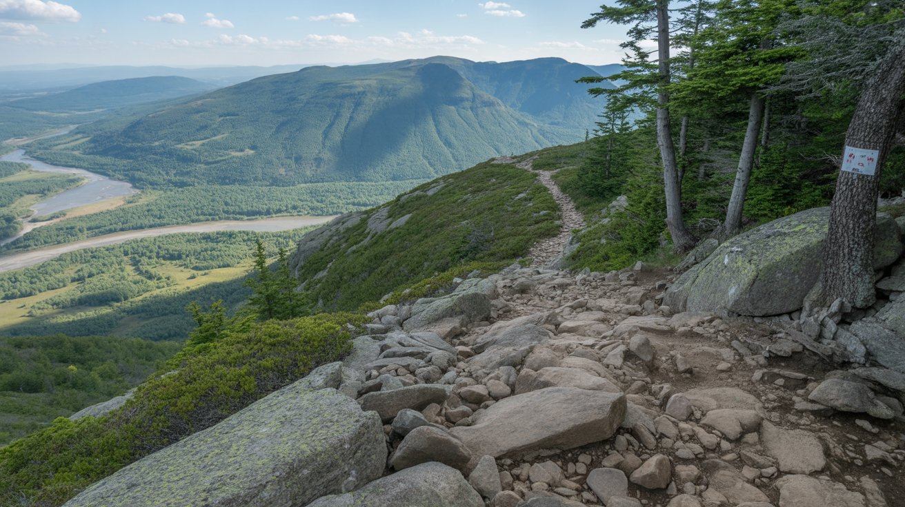
Steep Initial Climb
The hike starts with a steep climb where you’ll need to use your hands to scramble over boulders. This challenging first section tests your legs and gets your heart pumping immediately, so pace yourself and take breaks as needed.
Easier Middle Section
After the first 30 minutes, the trail becomes easier as you pass through forests and rocky areas. Your breathing settles and you can enjoy the surroundings more. This gentler section gives you a chance to recover before the final push.
Navigation and Trail Markers
The trail has colored blazes to guide you along the route. Watch trail junctions carefully so you don’t get lost or take a wrong turn. Download offline maps or bring a trail guide for backup navigation.
Don’t Stop at the First Viewpoint
Don’t stop at the first viewpoint you reach. Keep going to the true summit called the money spot for the best panoramic views. The extra effort is worth it when you see the full Hudson River spread out below.
Timing and Seasonal Considerations
Most hikers finish in 2.5 to 3.5 hours depending on pace and conditions. Weather and season can make it harder, with spring and fall being the best times to hike. Avoid icy winter conditions and extreme summer heat.
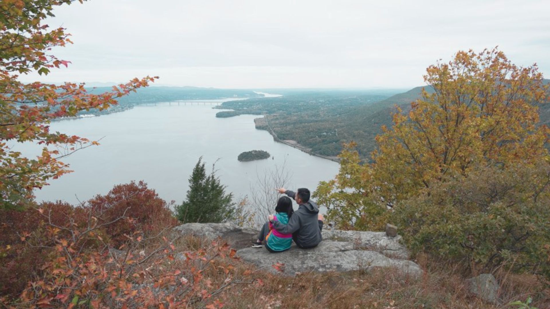
The Views from Storm King Mountain

The summit views make every step worth it. From the top, you’ll see the Hudson River stretching north and south like a silver ribbon through green valleys.
Look across the water and you’ll spot Bannerman’s Castle on Pollepel Island. This crumbling Scottish-style castle adds a historic touch to your photos. The Newburgh-Beacon Bridge spans the river to the south, and on clear days, you can see for miles.
The “money spot” refers to the rocky outcrop at the summit with zero trees blocking your view. Come at sunrise to catch amazing light and avoid crowds.
Trail Navigation and Key Waypoints
Start your hike by following clear trail markers and pay attention to critical decision points along the route.
Starting on the Orange Trail
Start your hike by following the Orange Trail from the parking lot. The trail is marked with orange blazes painted on rocks and trees.
This path takes you straight up the mountain through the rocky scramble section. Keep your eyes on the blazes, especially when the trail crosses open rock faces.
Critical Junction at Halfway Point
The most important junction comes about halfway through your hike at the split where the Orange Trail meets the Yellow and Blue Stillman Trail. Turn RIGHT here. This is critical. Turning left is a common mistake that takes you off course and adds unnecessary miles to your hike.
Completing the Loop or Returning
To complete the full loop, follow the trail to Butter Hill’s summit, then connect to the White Trail for your descent back to the parking area.
If you’re doing the shorter out-and-back route, just reverse your path on the Orange Trail. Trail blazes are generally easy to follow, but bring a map or download an offline trail map on your phone just in case.
Practical Tips for Hiking Storm King
- Plan to visit on a weekday morning if possible, as weekends fill the 20-car parking lot by 8 AM. Getting there early means easier parking and a quieter trail experience.
- Bring at least 1 liter of water per person, snacks, and hiking boots with good grip. Pack layers for changing weather, a first aid kit, fully charged phone, sunscreen, and bug spray.
- Dogs can come along but rock scrambles pose challenges for smaller pups. Keep dogs on a leash and consider their size, as rocky sections may require lifting them.
- Cell service works at the trailhead and summit but can be spotty in between. Download offline maps before you start since you can’t count on GPS.
- Pack out everything you bring since there are no trash cans on the trail. Stick to marked paths to protect the environment and avoid getting lost.
How to Reach Storm King Mountain Trailhead?
The Storm King Mountain trailhead is located on Route 9W in Cornwall-on-Hudson, New York, about 50 miles north of New York City. Multiple access routes make it reachable from various directions.
Driving Directions from NYC
Take the Palisades Interstate Parkway north to the Bear Mountain Bridge. Cross the bridge and continue north on Route 9W for approximately 8 miles. The small parking lot will be on your right side, marked with a hiking sign. The drive takes about 1.5 hours without traffic.
Driving from Other Locations
From the west, take I-84 east to Route 9W south. From northern areas, take Route 9W south directly. From Connecticut, cross the Newburgh-Beacon Bridge and head south on Route 9W. Watch carefully for the trailhead marker as it’s easy to miss.
Public Transportation Options
Metro-North Hudson Line runs to Cold Spring or Beacon stations. From there, you’ll need a taxi or rideshare to reach the trailhead, as no direct bus service exists. This adds time and cost to your trip, making driving the more practical option.
GPS Coordinates and Address
Use these GPS coordinates: 41.4297° N, 74.0042° W. The nearest address for navigation is Route 9W, Cornwall-on-Hudson, NY 12520. Look for the small parking area on the west side of Route 9W with space for about 20 vehicles.
Conclusion
The Storm King Mountain hike delivers what Hudson Valley hikers want most: big views from reasonable effort. You’ll work for those summit panoramas, but the trail doesn’t require expert skills or all-day commitment.
Rock scrambles add fun without being scary, and the river views from the top beat almost anything else in the area. This trail works for many skill levels, from first-timers with basic fitness to experienced hikers wanting a quick workout.
Check the weather before you go, bring enough water, and start early. Have you hiked Storm King? Share your experience in the comments below!
Frequently Asked Questions
Can Beginners Hike Storm King Mountain?
Yes, but be ready for a workout. The rock scrambles and steep start make this harder than typical beginner hikes, but with basic fitness you can do it.
Is Storm King Mountain Good for Dogs?
Dogs are allowed on leash, but rock scrambles require lifting smaller dogs. Consider your dog’s size and fitness before bringing them.
How Long Does It Take to Hike Storm King Mountain?
Most hikers finish in 2.5 to 3.5 hours for the full loop, or 1.5 to 2.5 hours for the shorter route. Your time depends on fitness level and stops.
What Is the Best Time of Year to Hike Storm King?
Fall offers the best weather and views, with peak colors in October. Avoid summer weekends when crowds and heat make hiking less enjoyable.
Are There Bathrooms at Storm King Mountain?
No bathrooms exist at the trailhead or along the trail. Use restrooms in Cornwall-on-Hudson before you arrive, about 10 minutes away.