

I’ve driven this iconic 50-mile stretch through Glacier National Park three times, and having a solid map changed everything.
This guide will show you how to read the road layout, which stops matter most, and how to avoid the mistakes I made on my first trip.
I’ve navigated closures, shuttles, and permit rules firsthand across different seasons. You’ll get clear route plans, shuttle tips, seasonal updates, and the best viewpoints.
I’m covering both entrances, wildlife zones, and photography spots. I’ve spent hours figuring this out so you don’t have to.
Let’s make your visit smooth and memorable.
What Is Going-to-the-Sun Road? (Quick Overview for Map Users)
This is the main scenic drive through Glacier National Park in Montana.
Quick facts:
The road runs 50 miles from west to east. It crosses the Continental Divide at Logan Pass (6,646 feet elevation).
You’ll see mountains, lakes, waterfalls, and wildlife.
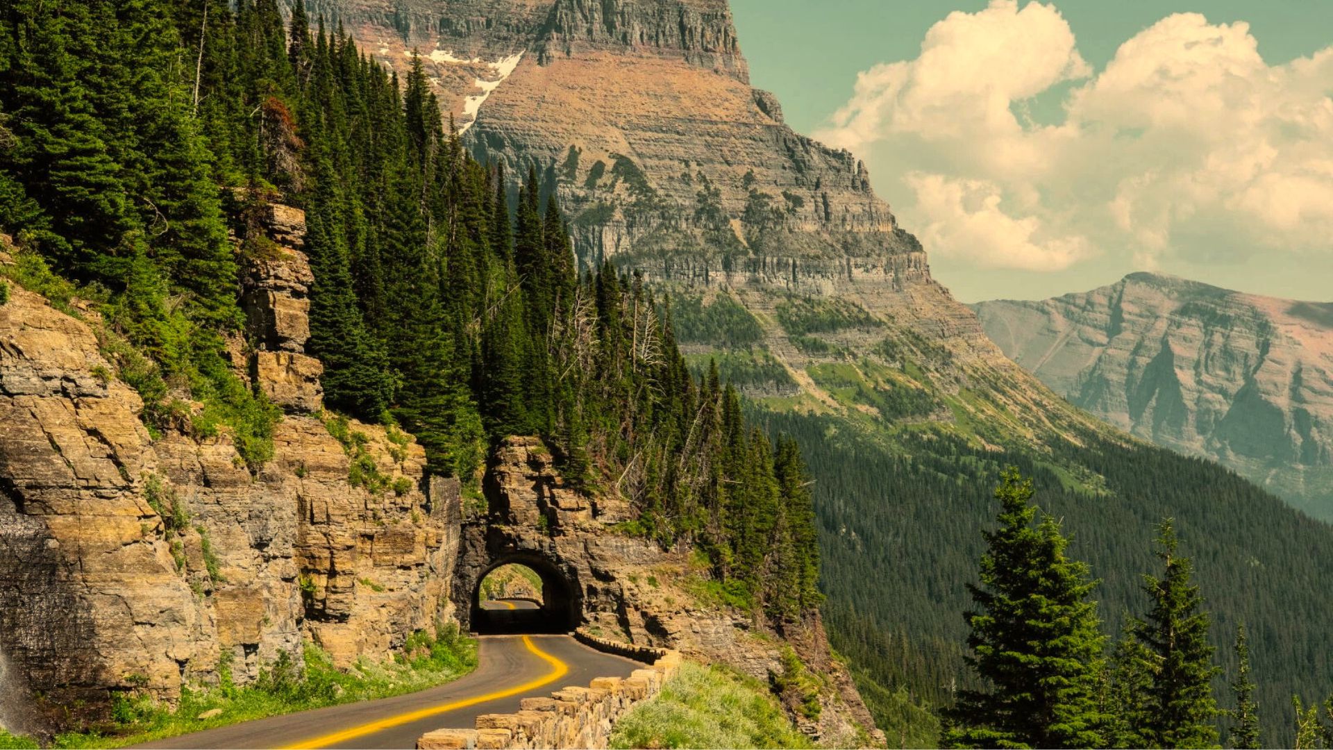
The road is narrow and winding with steep drop-offs in sections. Most vehicles can drive it, but large RVs and trailers face restrictions.
When it’s open:
Usually late June or early July through mid-October. Snow removal takes weeks (the road gets buried under 80 feet of snow).
Winter closes the entire route from November through June. The map shows two main entrances: West Glacier on one side and St. Mary on the other.
Going-to-the-Sun Road Map Explained
Your map shows more than just a line through the mountains. It marks visitor centers, trailheads, shuttle stops, and viewpoints.
Understanding the layout helps you plan your day better.
East vs West Entrance on the Map
The west entrance starts near Apgar and Lake McDonald. This side has thick forests and the largest lake in the park.
The terrain is greener and more wooded. The east entrance begins at St. Mary.
This side has open prairies and dramatic mountain views. The landscape feels wider and more exposed.
I prefer starting from the east because you face the mountains as you climb. The views hit differently when you’re driving toward them instead of away.
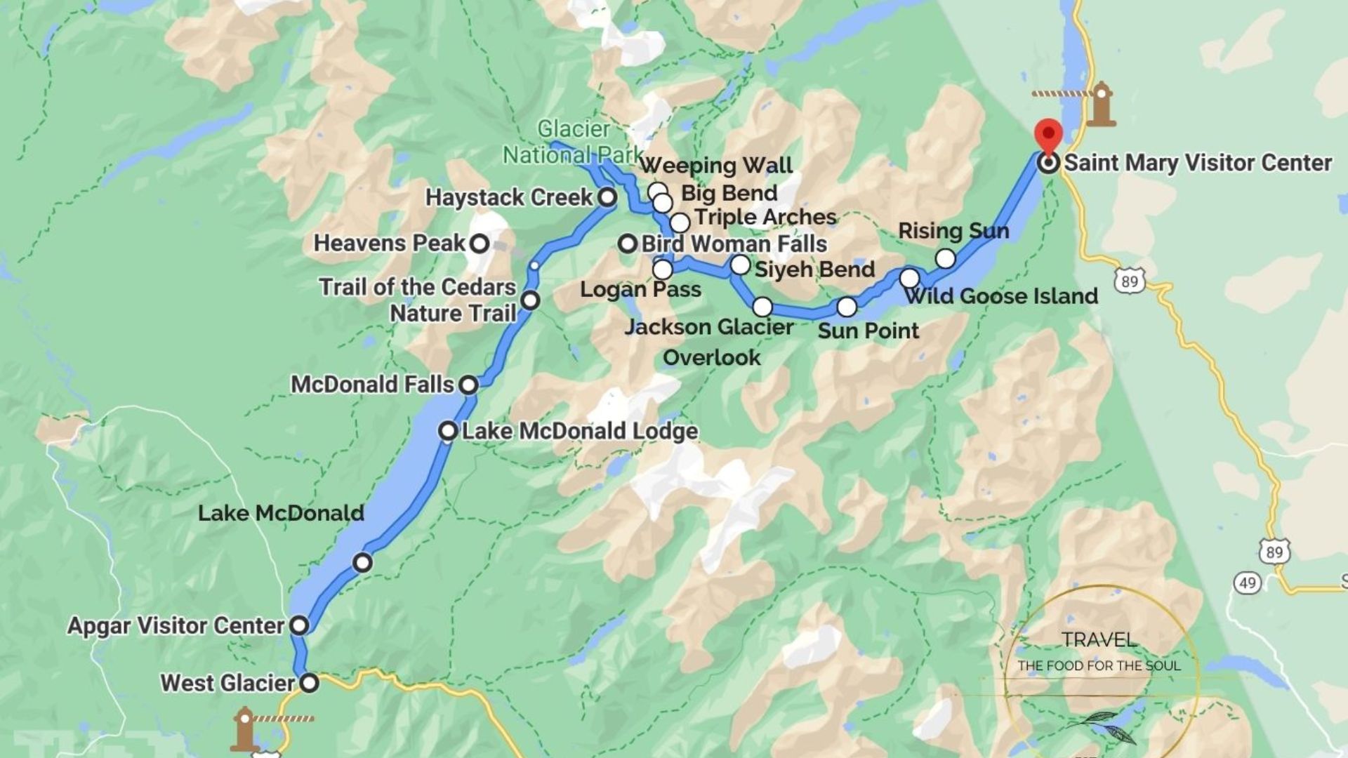
Mile-by-Mile Layout of Going-to-the-Sun Road
Mile 0 to Mile 10: West Glacier to Lake McDonald. Gentle curves through the forest.
Mile 10 to Mile 18: Lake McDonald to The Loop. The road starts climbing.
Mile 18 to Mile 32: The Loop to Logan Pass. Switchbacks and narrow sections. This is the dramatic part.
Mile 32 to Mile 42: Logan Pass to Big Bend. Descending on the east side. Sharp turns.
Mile 42 to Mile 50: Big Bend to St. Mary. Gradual descent with lake views.
Your map will show mile markers. Use them to track your progress and find stops.
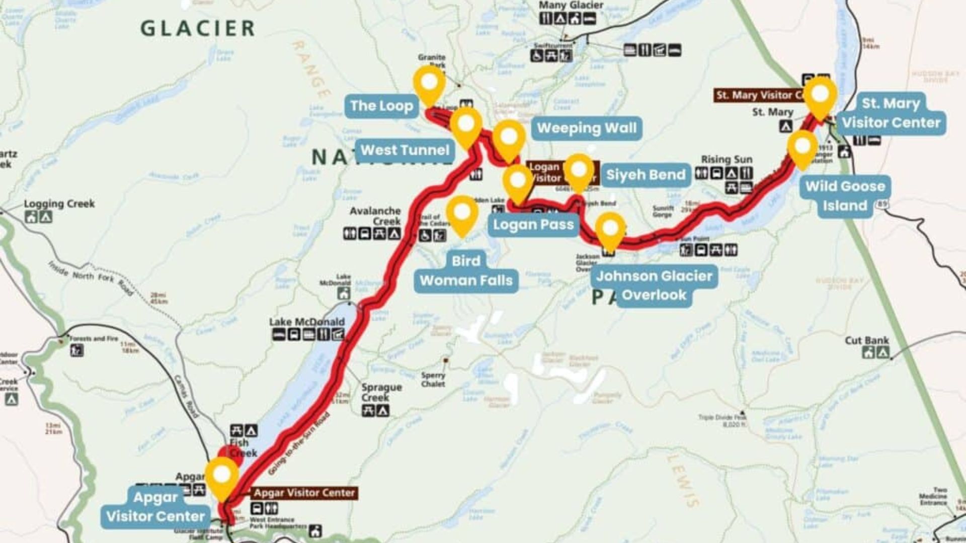
15 Must-Stop Places Marked on the Going-to-the-Sun Road Map
I’m listing these from west to east. You can do them in reverse if you start from St. Mary.
- Apgar Visitor Center: This is your first stop from the west entrance. Grab maps, ask rangers questions, and use the restrooms. The center sits near Lake McDonald.
- Lake McDonald: The biggest lake in Glacier National Park. Pull over at the lodge or the north shore pullout. The water is clear and cold. Mountains reflect on the surface on calm mornings.
- Avalanche Lake Trailhead: This trail is 4.5 miles round trip. It’s one of the most popular hikes in the park. The trailhead has a small parking lot that fills up fast.
- The Loop: A big hairpin turn with a parking area. You get a view of the valley below. Many people stop here for photos. It’s also a popular shuttle stop.
- Logan Pass Visitor Center: This is the top of the road at 6,646 feet. The Hidden Lake Trail starts here. I got there at 7:30 AM and still struggled to find parking.
- Hidden Lake Overlook: A 2.7-mile round trip hike from Logan Pass. The trail is mostly boardwalk. The overlook gives you a view of Hidden Lake below.
- Big Bend: Another sharp turn on the east side. Good spot to pull over and look at the valley. Less crowded than other viewpoints.
- Haystack Creek: A small pullout with a bridge. The creek runs under the road. Quick stop for a photo.
- St. Mary Lake: The second largest lake in the park. There are multiple pullouts along the south shore. Wild Goose Island is in the middle of the lake. It’s the most photographed spot here.
- Sunrift Gorge: A short walk to a narrow gorge. Water rushes through the rocks. The parking area is small. You might have to wait for a spot.
- Baring Falls: A short 1.3-mile round trip hike. The waterfall is wide and loud. The trail is easy and family-friendly.
- St. Mary Falls Trailhead: This trail is 2.6 miles round trip. You can also continue to Virginia Falls for a longer hike. The trailhead has decent parking.
- Rising Sun: A campground and small store. Good place to take a break. Restrooms and picnic areas available.
- Siyeh Bend: A big curve in the road. Offers views of the surrounding peaks. Not as busy as other stops.
- St. Mary Visitor Center: The last stop on the east side. Another place to ask questions and use facilities. Good spot to wrap up your trip.
Going-to-the-Sun Road Map for First-Time Visitors
Your first time on this road can feel intense. I remember gripping the steering wheel and wondering if I made the right call.
But with a plan, it’s totally doable.
Best Direction to Drive (East to West or West to East?)
I’ve done both directions.
Driving east to west means you face the mountains as you climb. The views are in front of you instead of behind you.
You’ll also be on the inside lane during the narrow sections. That feels safer if you’re nervous about heights.
Driving west to east puts you on the outside lane with drop-offs. But you get great views of St. Mary Lake as you descend.
I recommend going east to west for your first time.
Where to Start If You Have Limited Time
If you only have a few hours, start at Logan Pass. Get there early and hike the Hidden Lake Trail.
Then drive east toward St. Mary and stop at Wild Goose Island Overlook.
Or drive west toward The Loop and stop at Avalanche Lake. This gives you the highlights without driving the entire road.
One-Day vs Half-Day Map Route Plans
One-day plan: Drive the full road. Start early. Hit Logan Pass by 8 AM. Stop at Lake McDonald, Avalanche Lake, Logan Pass, Wild Goose Island, and Sunrift Gorge. Plan for 6 to 8 hours.
Half-day plan: Drive from Logan Pass to either end. Stop at 3 to 4 viewpoints. Plan for 3 to 4 hours.
Your map will help you mark the stops you care about most.
Seasonal Map Changes You Must Know Before You Go
Always check current conditions before you go. The park website has real-time updates on openings and closures.
Snow still covers parts of the high country. Logan Pass might have 10-foot snow walls on both sides.
July and August: Everything is green. Wildflowers bloom. Crowds peak.
September: The larches turn gold on the east side. Crowds thin out. This is my favorite time.
October: The road starts closing in sections.
November through June: Winter closes the entire road. You can’t drive it.
Your Glacier National Park road map won’t show these seasonal changes. Weather at Logan Pass can shift fast even in summer.
Going-to-the-Sun Road Map With Shuttle Stops
The park runs a free shuttle system. It’s a great option if you don’t want to deal with parking.
Free Shuttle Route Explained
The shuttle runs from Apgar to St. Mary. It stops at all major viewpoints and trailheads.
Shuttles run every 15 to 30 minutes depending on the time of day. You can hop on and off as much as you want. The shuttle runs from early July through early September.
Best Shuttle Stops for Scenic Views
Logan Pass is the top stop. But you’ll have to wait in line to get on. The Loop offers great valley views without the chaos.
Avalanche Creek gives you access to the Avalanche Lake hike. St. Mary Falls Trailhead is less crowded and still gorgeous.
How to Combine Driving + Shuttle Using the Map
I’ve done this before and it worked great. Drive to Logan Pass super early. Park your car there.
Take the shuttle west toward Lake McDonald. Stop at The Loop and Avalanche Lake. Shuttle back to Logan Pass. Drive the rest of the road east.
This way you avoid the parking nightmare at Logan Pass later in the day.
Best Time to Visit Using the Road Map
Early morning is the best time. I’m talking from 6 to 8 AM. The light is soft. Animals are active. Parking is easier.
Midday gets crowded. Parking lots fill up. The sun is harsh for photos. Late afternoon is nice too. The crowds start to thin. The light gets golden.
Weekdays are better than weekends. September is the sweet spot for me. Fewer people. Better weather. Fall colors.
Common Mistakes People Make Using a Going-to-the-Sun Road Map
Not arriving early enough. Logan Pass parking fills up by 8 AM. I learned this the hard way.
Underestimating drive time. The speed limit is 25 to 35 mph. Add stops and you’re looking at 3 to 4 hours minimum.
Not checking the weather. It can snow at Logan Pass even in July.
Forgetting food and water. There are limited places to buy supplies on the road.
Relying only on phone GPS. Cell service is spotty. Download offline maps or bring a paper version.
Not checking vehicle restrictions. RVs over 21 feet and vehicles over 8 feet wide can’t drive the full road.
Final Tips for Navigating Going-to-the-Sun Road Confidently
- Fill up your gas tank before you start. There are no gas stations on the road.
- Pack layers. It can be 70 degrees at Lake McDonald and 40 degrees at Logan Pass.
- Bring snacks and water. You’ll be out longer than you think.
- Use pullouts to let faster drivers pass. Don’t stop in the middle of the road for photos.
- Keep your scenic drive map handy. Mark the stops you want to hit before you start driving.
- Give yourself extra time. Rushing takes away from the experience.
- Be flexible. If a parking lot is full, move to the next stop.
This road is incredible. I still think about my drives every time I see photos from Glacier. You’re going to love it.
Conclusion
This guide should make planning your Glacier National Park drive much easier.
The road is one of the best in America, but it takes preparation. Start early, bring your map, and don’t skip the smaller stops between famous ones.
Check official park updates before you go and stay flexible with your plans. The views are worth every bit of effort. Print your map or save it offline because cell service disappears fast.
If this helped you, share it with someone planning their trip.
Frequently Asked Questions
Can I drive Going-to-the-Sun Road in one day?
Yes, plan for 6 to 8 hours including stops. Start early to get parking at Logan Pass.
When does Going-to-the-Sun Road fully open?
Usually late June or early July through mid-October. Check the park website for current status.
Do I need a special permit to drive this road?
You need a park entrance pass. During peak seasons, vehicle reservations may be required. Check official park updates before visiting.
Is Going-to-the-Sun Road dangerous to drive?
It’s safe if you drive carefully. The road is narrow with tight turns and drop-offs.
What’s the best map app for this road?
Download offline maps before you go. Google Maps offline mode works, or grab the official park paper map.